
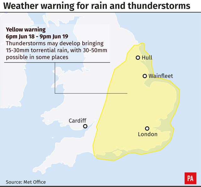
More weather warnings have been put in place as thunderstorms, torrential rain and flooding look set to batter parts of the UK again.
The Met Office has issued a yellow warning for the South East, East Anglia, the East Midlands and some of the North East as strong winds and lightning strikes are also expected.
Forecasters have said the storms and floods could cause power cuts, train and bus delays and disruption for drivers.
The warning states: “Thunderstorms may develop, bringing torrential rain, hail and lightning to a few places, with potential disruption to travel and flooding.
“There is a small chance that homes and businesses could be flooded quickly, with damage to some buildings from floodwater, lightning strikes, hail or strong winds.
“Where flooding or lightning strikes occur, there is a chance of delays and some cancellations to train and bus services.”
The Met Office warning adds: “Spray and sudden flooding could lead to difficult driving conditions and some road closures.
“There is a slight chance that power cuts could occur and other services to some homes and businesses could be lost.”
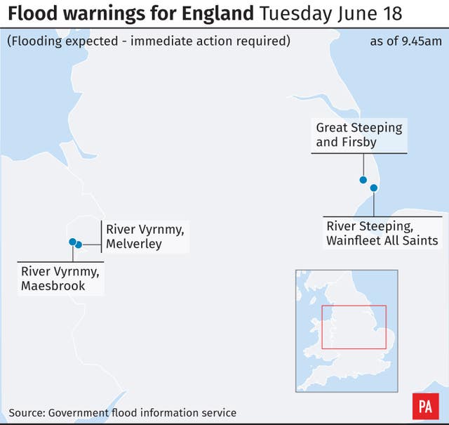
Some flood-hit communities, such as Wainfleet in Lincolnshire, look set to face further damage, despite having already seen around 225 Olympic-sized swimming pools’ worth of water pumped out to sea.
Lincolnshire Police said almost 600 homes remain evacuated as the clean-up operation continues, while around 350 tonnes of sand and ballast were dropped in the area by RAF Chinook helicopters over the weekend.
Heavy #showers and #thunderstorms have been moving north across the English Channel over the past few hours. Here's the latest: ⚡️⚡️ pic.twitter.com/uXRysvPEOc
— Met Office (@metoffice) June 18, 2019
Doug Wilson, flood duty manager at the Environment Agency, has said the flood risk in the town will remain until Saturday.
He said: “In Lincolnshire, Environment Agency staff are working 24/7 alongside the emergency services to protect people and property after a river embankment breached at Wainfleet.
“In an effort to reduce flood waters, our field teams will be operating an ultra-high volume pump on Tuesday.
“There will continue to be an increased flood risk in the Wainfleet area until Saturday, with a risk of heavy thundery showers today, and more prolonged showers tomorrow.
Mr Wilson added: “The county has already seen over three times the amount of rain which normally falls in a month.
“More widely across the country, heavy and persistent thunderstorms today and tomorrow will bring a risk of surface water and river flooding for southern, central and eastern England.
“We are monitoring the situation and will work with our partners, including local authorities, to take preventative action where necessary.”
Despite the predicted rainfall in Wainfleet, the Environment Agency said it is “ready to act as needed” if more flooding hits the town.
After two months’ worth of rain fell in just two days, the residents who managed to avoid being evacuated have been asked to avoid using washing machines and sparingly use toilets and showers.
Other areas will be cloudy on Tuesday, with showers expected across Scotland, Northern Ireland and the South West of England.
The Met Office said North Wales and northern England will be warm and bright throughout the day.


Comments: Our rules
We want our comments to be a lively and valuable part of our community - a place where readers can debate and engage with the most important local issues. The ability to comment on our stories is a privilege, not a right, however, and that privilege may be withdrawn if it is abused or misused.
Please report any comments that break our rules.
Read the rules here